![]()
|
A-K Information Sources
|
| Code | Reference Details |
| AWM | Australian War Memorial Resources |
| DM | The Daily Mercury Newspaper; published by Mackay Printing and Publishing Co. |
| ELF | Email recieved From Mr. Lyall Ford |
| FOF | Faith of our Fathers, A journey of three Fatnownas 1866-1999, by Teresa Fatnowna, published 2002. |
| HCS | Heritage Context Study for the Mackay City Council Town Planning Review; by Berenice Wright, Anne Jacobs and Roger Dalton; July 1996 |
| MHS | The Mackay Harbour Story, by H.A. Moore, 1978, Mackay Harbour Board, Mackay. |
| PN | Pioneer News Newspaper, Mackay. |
| QPH | Queensland Political Portraits 1859-1952, edited by D.J. Murphy and R.B. Joyce, 1978, University of Queensland Press, Brisbane. |
| QPP | Three Decades of Queensland Political History 1929-1960, edited by Clem Lack, 1961?, Government Printer, Brisbane. |
| REF | Reflections - 125 years of Education , Mackay Central State School; by Mackay Central State School 125 years Celebration Committee; published 1996 |
| SN | Scrubby News, Volume 1, Number 3, December 1991, published by Walkerston Neighbourhood Centre Group |
| TWI | The Whitsunday Islands - An Historical Dictionary; by Ray Blackwood; published 1997 |
|
Street Name |
Locality |
Named after |
Details & Reference Sources |
| Abel Tasman Court | Rural View | Australian Explorers | |
| Aberdeen Court | Beaconsfield | Scottish Locations | |
| Absolon Street | South Mackay | Subdivider | (HCS
pp.141) Eric & Joyce Absolon had 5 acres in Archibald Street and not long after they bought this land the Housing Commission started to build on land nearby. Eric said that they decided to give the council one acre of land so that a street could be put in to open up the area which would also be an advantage to them. At this time there was an article in the Daily Mercury saying that the council was having some difficulty finding street names so Eric wrote to the council suggesting Absolon Street for the street being put in on the acre of land that he had given. He told them he would like it named after his grandfather, John Absolon (1840-1904), who was one of the early pioneers of Mackay and district. Absolon Street was accepted. (Source: Email D. Jeppesen 19 Aug. 2009) |
| Absy Court | Glenella | ||
| Acacia Court | Andergrove | Australian Flora | |
| Acacia Street | Seaforth | Australian Flora | |
| Adair Court | Eimeo | ||
| Adams Court | South Mackay | ||
| Adele Court | Andergrove | ||
| Admiral Drive | Dolphin Heads | ||
| Admirality Way | Shoal Point | ||
| Adrian Street | West Mackay | WW2 Casualty | Named after Robert Andrew Adrian who served in the 2nd A.I.F. and was attached to the 31/51 Battalion when he was killed in Action on 31 January 1945 in the Solomon Islands. He is buried in the Port Moresby (Bomana) War Cemetery in New Guinea. (AWM 147),(HCS pp.141) |
| Aileen Court | Andergrove | ||
| Aitken Street | West Mackay | WW2 Casualty | (HCS pp.141) |
| Alan Naish Court | Eimeo | ||
| Albatross Street | Slade Point | ||
| Albert Street | Andergrove | ||
| Albert Street | Mackay | Name changed to Gordon Street in 1930's to avoid confusion with Alfred Street. | |
| Aldo Court | Glenella | ||
| Alec Dick Court | Seaforth | ||
| Alexander Street | Eimeo | ||
| Alexandra Street | Meadowlands | Royal Family | Queen
Alexandra?; previously Alexander Street; Alexandra was the name proposed
for Mackay in Fitzgerald's 1863 survey (HCS pp.141) |
| Alexandra Street | Ooralea | Royal Family | see above |
| Alexandria Road | Alexandra | ||
| Alexandria Road | Walkerston | Allegedly named after the Alexandria housing estate developed in the early 1970's on the former site of the Alexandra sugar mill. Was previously known as the "Palmyra" Road. | |
| Alfred Street | Mackay | Royal Family | Son
of Queen Victoria (HCS pp.141) |
| Alison Court | Slade Point | ||
| Allan Court | Ooralea | Subdivider's Family | Plath
Family & names (HCS pp.153) |
| Allandale Street | South Mackay | ||
| Alma Court | North Mackay | ||
| Amanda Drive | Andergrove | ||
| Amelia Drive | North Mackay | ||
| Amhurst Street | Slade Point | Local Pioneer | Named after Francis Tyssen Amhurst who developed the Foulden Sugar Mill in 1871. He was in Queensland Parliament from 1875 to his death in 1881. The suburb of Slade Point was previously known as "Amhurst" |
| Amiet Street | South Mackay | Local Identity? | Possibly named after William Amiet a local solicitor. |
| Amstead Street | Eimeo | Local Pioneer? | Possibly named after James Amstead who was licensee of the Eimeo Hotel from 1925 to 1927. |
| Andergrove Road | Andergrove | ||
| Andrew Court | Andergrove | ||
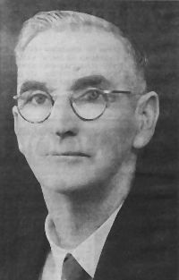
| Andrew Milne Drive | Mount Pleasant | Local Identity | |
| Anglers Parade | Blacks Beach | ||
| Anita Drive | Andergrove | ||
| Anne Street | Walkerston | ||
| Annie Wood Avenue | Mount Pleasant | Named in honour of former Mayor Ian Wood's mother. Was originally part of "Bona Vista" estate which was owned by the Croker family and afterwards by Ian Wood. | |
| Annmore Court | Andergrove | ||
| Anthony Vella Street | Rural View | ||
| Anvil Street | Slade Point | ||
| Apollo Drive | Andergrove | ||
| Apsley Way | Andergrove | ||
| Aquatic Place | Blacks Beach | ||
| Arana Drive | Eimeo | ||
| Archibald Street | Paget | ||
| Archibold Street | Seaforth | ||
| Arcturus Street | North Mackay | ||
| Argyle Court | Beaconsfield | ||
| Armitage Drive | Eimeo | ||
| Armstrong Street | Farleigh | ||
| Arthur Street | Mount Pleasant | ||
| Ash Street | Slade Point | ||
| Atkinson Street | East Mackay | ||
| Avalon Drive | Eimeo | ||
| Avocado Court | Beaconsfield | ||
| Azalea Court | Beaconsfield | ||
| Badila Court | Mount Pleasant | Sugar Cane Variety | |
| Bagley Street | West Mackay | Early
Pioneer? WW1 Casualty? |
William Bagley publican of Great Northern Hotel, Eton, 1865; H.G. Bagley KIA WW1; C.F. & J.J. Bagley (HCS pp.141) |
| Bakker Crescent | Eimeo | ||
| Bald Hill Road | Glenella | ||
| Baler Street | Shoal Point | ||
| Balmoral Court | Beaconsfield | Scottish Locations | |
| Banksia Avenue | Andergrove | Australian Flora | |
| Bankswood Street | Beaconsfield | ||
| Bannister Street | South Mackay | ||
| Barbat Court | Andergrove | ||
| Barber Drive | Eimeo | ||
| Barcoo Road | Habana | ||
| Barlow Street | Walkerston | ||
| Barnes Creek Road | Cremorne | Local Pioneer | John Greenwood Barnes was the first settler in the North Mackay area at Cremorne. |
| Barnes Road | Richmond | ||
| Barnfield Drive | Andergrove | ||
| Barramundi Court | Andergrove | Fish | |
| Barton Street | West Mackay | Local Identity | Sir Charles Barton - Mackay Engineer and Commissioner of Main Roads (HCS pp.141) |
| Bartrop Street | Beaconsfield | ||
| Bassett Street | North Mackay | ||
| Bath Avenue | Ooralea | ||
| Baur Street | North Mackay | ||
| Baxter Drive | Mount Pleasant | ||
| Baxter Street | Mackay | WW1 Casualty | Jack Baxter, died wounds WWI, 1918 (HCS pp.141) |
| Beach Road | Dolphin Heads | ||
| Beach Road | Mackay | Original name for Evan Street. | |
| Beaconsfield Road | Beaconsfield | ||
| Beaton Street | West Mackay | ||
| Beckett Court | Ooralea | ||
| Bedford Road | Andergrove | Local Family | was originally known as Slade Point Road until the now Slade Point Road was constructed. Named Bedford Road after various members of the Bedford family who owned land along its route. (Email P & K Morrow, 30/10/2010) |
| Begonia Court | Beaconsfield | ||
| Belbin Street | Blacks Beach | ||
| Ben Nevis Street | Beaconsfield | Scottish Locations | |
| Benaud Street | Glenella | Australian Cricketer | Richie Benaud |
| Benbow Court | Mount Pleasant | ||
| Benham Street | Andergrove | ||
| Benson Avenue | Mount Pleasant | ||
| Bernborough Avenue | Ooralea | Race Horse | (HCS pp.141) |
| Berry Street | North Mackay | ||
| Beschen Court | Blacks Beach | ||
| Beth Street | Blacks Beach | ||
| Beverley Street | South Mackay | Island Group | (HCS pp.141) |
| Bezzina Court | Bucasia | ||
| Binnington
Esplanade
|
East Mackay | Former Mayor | John (Jack) Binnington, Mayor 1952 to 1967(HCS pp.141) |
| Birditt Court | Glenella | ||
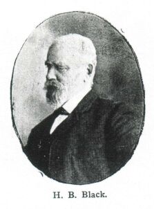
| Black
Street
|
South Mackay | Former Mayor | Henry Bowyer Black, Mayor 1891, 1895, 1897; also H.L. Black, Mayor 1888(HCS pp.142) |
| Blackall Court | Mount Pleasant | ||
| Blacks Beach Road | Blacks Beach | ||
| Blacksmith Street | Slade Point | ||
| Blackwood Street | Slade Point | ||
| Bligh Court | Mount Pleasant | ||
| Blue Gum Drive | Glenella | ||
| Boddington
Street
|
Mackay | WW1 Casualty | 1917 After two sons of F.W. Boddington, KIA WW1' one was an architect (Frederick Eckersley Boddington) (HCS pp.142) |
| Boden Street | Bucasia | ||
| Bold Street | Walkerston | ||
| Bona Vista Drive | Mount Pleasant | named after "Bona Vista" estate owned by the Croker Family and later by Ian Wood. | |
| Border Street | Glenella | Australian Cricketer | Allan Border |
| Borg Court | Beaconsfield | ||
| Botha Street | Blacks Beach | ||
| Bothwick Street | East Mackay | ||
| Boulton Street | South Mackay | ||
| Boundary Road | Paget | Original
City Boundary (HCS pp.142) |
|
| Bourke Street | Blacks Beach | ||
| Bovey Road | Nindaroo | ||
| Bovey Street | North Mackay | ||
| Bowen Court | Mount Pleasant | ||
| Bower Street | Slade Point | Australian Bird | |
| Bowerman Street | Blacks Beach | ||
| Bowman Street | West Mackay | ||
| Bracken Street | Slade Point | ||
| Bradford Street | North Mackay | ||
| Bradman Drive | Glenella | Australian Cricketer | Sir
Donald Bradman ( 1908-2001) |
| Brake Street | North Mackay | ||
| Brampton Avenue | Bucasia | ||
| Brand Court | Beaconsfield | ||
| Brandon Street | South Mackay | ||
| Branscombe Road | Walkerston | Sugar Mill | Named after Branscombe Mill and Plantation |
| Bream Court | Andergrove | Fish | |
| Breckell Court | Slade Point | ||
| Brickworks Court | Glenella | ||
| Bridge Road | West Mackay | To Pioneer River Bridge (HCS pp.142) | |
| Bridge Street | Walkerston | ||
| Brimelow Street | Bucasia | ||
| Brisbane Street | Mackay | Queensland Governor | Named by Thomas Henry Fitzgerald in his original survey of Mackay township in 1863. Governor Brisbane (HCS pp.142) |
| Broadsound Road | Paget | To
Broadsound (HCS pp.142) |
|
| Brolga Street | Slade Point | Australian Bird | |
| Bronte Street | West Mackay | Author | Bronte
sisters (HCS pp.142) |
| Brooks Street | West Mackay | ||
| Broomdykes Drive | Andergrove | ||
| Bruce Highway | |||
| Bucas
Drive
|
Bucasia | Local Pioneer | Father Pierre Marie Bucas owned most of the land in Bucasia and Shoal Point in the late 1800's and started an ill fated orphanage in the area in the 1880's. |
| Bundesen Street | North Mackay | ||
| Burge Street | Glenella | Australian Cricketer | Peter Burge |
| Burgess Street | North Mackay | ||
| Burns Street | Mackay | Poet | Named
by Thomas Henry Fitzgerald in his first survey of the Mackay township in
1863. Robbie Burns (HCS pp.142) |
| Burston Street | North Mackay | WW2 Casualty | Named after Hec Burston who served with the A.I.F. and was killed in the 2nd World War. (DM 26 May 1993. p. 7.) |
| Burton Court | Eimeo | ||
| Burwood Close | Andergrove | ||
| Busuttin Drive | Eimeo | ||
| Butler Street | Bucasia | ||
| Byron Street | Mackay | Poet | Named
by Thomas Henry Fitzgerald in his first survey of the Mackay township in
1863. Lord Byron (HCS pp.142) |
| Cabbage Tree Road | Andergrove | ||
| Cahill Crescent | Eimeo | ||
| Caledonian Drive | Beaconsfield | Scottish Locations | |
| Callan Court | Eimeo | ||
| Calliandra Court | Andergrove | ||
| Calrossie Road | Te Kowai | ||
| Cambridge Avenue | Andergrove | ||
| Cameron Street | East Mackay | Mayor | G.M. Cameron, Mayor, 1920(HCS pp.142) |
| Cameron Street | North Mackay | ||
| Camerons Road | Walkerston | Original Landowner | Named after the Cameron Family. Allan Cameron had his slaughter yard and piggery in this area supplying his butcher shop. (SN) |
| Camilleri Road | Eimeo | ||
| Campbell Street | Beaconsfield | ||
| Campbell Street | Slade Point | ||
| Campbell Street | South Mackay | ||
| Canberra Street | North Mackay | ||
| Cannan Street | South Mackay | Reef | (HCS pp.142) |
| Canter Lane | Bucasia | ||
| Carbeen Street | Andergrove | ||
| Carbine Street | Ooralea | Race Horse | (HCS pp.142) |
| Caribaea Court | Andergrove | ||
| Carl Murray Street | Beaconsfield | ||
| Carlyle Street | Mackay | Poet, English | (HCS pp.142) |
| Carne Court | Eimeo | Brisbane Bronco Rugby League Players | Willie Carne |
| Caroval Drive | Rural View | ||
| Carr Street | North Mackay | ||
| Carroll Street | Blacks Beach | ||
| Casey Avenue | South Mackay | Jack Casey (Ex Mackay City Council Alderman)(HCS pp.142) | |
| Cassia Place | Glenella | ||
| Cassia Street | Beaconsfield | ||
| Casuarina Street | Slade Point | Australian Flora | |
| Cathy Court | Slade Point | ||
| Cavanagh Drive | Blacks Beach | ||
| Cedar Court | Eimeo | ||
| Celeber Drive | Beaconsfield | ||
| Cemetery Road | West Mackay | To Cemetery(HCS pp.142) | |
| Central Drive | Andergrove | ||
| Chain Street | Mackay | Reef | (HCS pp.142) |
| Challenger Street | Beaconsfield | ||
| Chapman Court | Eimeo | ||
| Chappell Court | Glenella | Australian Cricketer | |
| Charles Court | Andergrove | ||
| Charles Hodge Avenue | Mount Pleasant | ||
| Charlmay Court | Meadowlands | ||
| Chataway Street | West Mackay | WW2 Casualty | Two Chataway boys lost in WWII, sons of James Cosmo Mant Chataway .(HCS pp.142) |
| Chauvel Street | South Mackay | Reef | (HCS pp.143) |
| Chelsea Crescent | Glenella | ||
| Cheribon Avenue | Mount Pleasant | ||
| Chidlow Street | Farleigh | ||
| Chris Court | Walkerston | ||
| Christensen Street | Bucasia | ||
| Christie
Street
|
East Mackay | Mayor | J. Christie, Mayor 1910-1911.(HCS pp.143) |
| Christine Drive | Nindaroo | ||
| Christines Way | Eimeo | ||
| Christo Court | Bakers Creek | ||
| Christoe Street | Farleigh | ||
| Christopher Court | Eimeo | ||
| Churchill Street | Ooralea | British Prime Minister | Winston Churchill(HCS pp.143) |
| Cinnamon Drive | Glenella | ||
| City View Court | Mount Pleasant | ||
| Clark Street | South Mackay | ||
| Clarke Court | Seaforth | ||
| Clear Vista Crescent | Mount Pleasant | ||
| Clements Street | South Mackay | Early Street, named for Clements-landowner and cemetery Sexton.(HCS pp.143) | |
| Clifton Court | Slade Point | ||
| Clipper Court | Bucasia | ||
| Coakley Court | Erakala | ||
| Coatbridge Court | Beaconsfield | Scottish Locations | |
| Cocos Court | North Mackay | ||
| Colby Court | Beaconsfield | ||
| Coles Road | Andergrove | ||
| Comino Court | South Mackay | WW2 Casualty | named after Jack Comino who died whilst a POW of the Japanese at Singapore in 1943. (DM 25/11/1992) |
| Commercial Avenue | Paget | Industrial Estate | |
| Cone Street | Shoal Point | Shell | |
| Connors Road | Paget | ||
| Conrock Avenue | Andergrove | ||
| Contor Drive | Bakers Creek | ||
| Cook Street | Bucasia | ||
| Cooks Lane | Bakers Creek | ||
| Cooney Street | Andergrove | ||
| Coral Court | North Mackay | ||
| Coral Drive | Blacks Beach | ||
| Coral Ridge Drive | Eimeo | ||
| Corney Street | North Mackay | ||
| Cornwall Street | North Mackay | ||
| Corporate Avenue | Paget | ||
| Corporate Drive | Paget | ||
| Cosford Court | Eimeo | ||
| Cowley Court | Mount Pleasant | ||
| Cowleys Road | Te Kowai | ||
| Cowrie Street | Blacks Beach | ||
| Coyne Street | South Mackay | WW1 Casualty | named after David Emmett Coyne. WWI Albert Medal Winner. |
| Craig Street | North Mackay | ||
| Crane Street | Slade Point | Australian Bird | |
| Creal Street | East Mackay | Reef | Named after Creal Reef on the eastern side of Hydrographers Passage was named in the late 1920's by Captain J.A. Edgell RN in HMAS Moresby. It is after Flying Officer Denis A.J. Creal who was one of the pilots with RAAF Flight 101 based at Bowen from 1926 to 1928 assisting Moresby with her surveys. (TWI pp55)&(HCS pp.143) |
| Credlin Street | South Mackay | Reef | Named after Credlin Reef on the barrier east of of Shaw Island. It was named by Lieutenant Commander H.T. Bennett, RAN, in HMAS Geranium which surveyed the area in 1925-1926. The name is after Lieutenant Alfred L. Credlin on board Geranium.(TWI pp55) &(HCS pp.143) |
| Creek Street | North Mackay | ||
| Creek Street | Walkerston | ||
| Creese Street | Beaconsfield | ||
| Cremorne Street | Cremorne | ||
| Crispin Drive | Mount Pleasant | ||
| Crowley Drive | West Mackay | Subdivider's Family | (HCS pp.143) |
| Crowleys Road | Meadowlands | ||
| Cruckhorn Drive | Subdivider's Family | Subdivider, Jim Cruckhorn(HCS pp.153) | |
| Culhene Court | Beaconsfield | ||
| Cullen Street | West Mackay | Marine Surveyor | |
| Culoden Place | Beaconsfield | ||
| Cumberland Avenue | Slade Point | ||
| Curlew Street | Slade Point | Australian Bird | |
| Currawong Street | Slade Point | Australian Bird | |
| Cuthbert Court | Slade Point | ||
| Cutler Drive | Beaconsfield | ||
| Cypress Court | Beaconsfield | ||
| Dale Court | Andergrove | ||
| Dallas Court | Beaconsfield | ||
| Dalrymple
Street
|
East Mackay | Mayor | David Hay Dalrymple, Mayor 1869-71, 1873-74.(HCS pp.143) |
| Damien Street | Eimeo | ||
| Dampier Drive | Andergrove | Australian Explorers | |
| Danastas Avenue | Eimeo | ||
| Dane Street | Walkerston | Named after the Dutch family of Jack Mezger's Waggonworks. (SN) | |
| Danelles Way | Eimeo | ||
| Daniel Court | Ooralea | ||
| Daniel Street | North Mackay | ||
| Dapplewood Close | Andergrove | ||
| Darling Street | Mount Pleasant | ||
| Darren Court | Bucasia | ||
| Davey Street | Glenella | ||
| David Muir Street | Slade Point | ||
| Davidson Street | Walkerston | ||
| Davinelle Close | Andergrove | ||
| Davlyn Drive | Andergrove | ||
| Deborah Court | Andergrove | ||
| Deguaras Drive | Beaconsfield | ||
| Dell Court | Beaconsfield | ||
| Delma Street | Andergrove | ||
| Denham Crescent | Rural View | Queensland Premiers | |
| Denise Court | Beaconsfield | ||
| Denman Avenue | Shoal Point | ||
| Dennis Street | South Mackay | WW2 Casualty | (HCS pp.143) |
| Dent Street | Walkerston | Named after the long time residents, the Dent Families. It was the depot of Harvison and Dent's Bus Service. (SN) | |
| Denton Street | South Mackay | Reef | (HCS pp.143) |
| Desbois Street | North Mackay | ||
| Deshong Street | Walkerston | ||
| Dewar Street | Bakers Creek | ||
| Diamond Court | Mount Pleasant | ||
| Dickens Avenue | Ooralea | Author | Charles Dickens(HCS pp.143) |
| Digby Street | South Mackay | Reef | (HCS pp.143) |
| Dimmock Street | South Mackay | WW2 Casualty | (HCS pp.143) |
| Dixon Court | Beaconsfield | ||
| Dobel Court | Mount Pleasant | ||
| Dolby Court | North Mackay | ||
| Dolphin Drive | Bucasia | ||
| Dolphin Heads Road | Dolphin Heads | ||
| Domino Court | Andergrove | ||
| Don Street | West Mackay | ||
| Don Wright Court | Andergrove | ||
| Donaldson Street | West Mackay | ||
| Doris Street | Andergrove | ||
| Douglas Street | West Mackay | WW2 Casualty | (HCS pp.143) |
| Downie Avenue | Bucasia | ||
| Downing Street | Ooralea | ||
| Driftwood Court | Eimeo | ||
| Du Maurier Court | Writer | Daphne Du Maurier | |
| Dudley Place | Slade Point | ||
| Dugong Place | Andergrove | ||
| Duke Court | Eimeo | ||
| Dumfries Court | Beaconsfield | Scottish Locations | |
| Duncan Street | West Mackay | ||
| Dundee Court | Beaconsfield | Scottish Locations | |
| Dunn Street | West Mackay | ||
| Dupuy Street | West Mackay | Local Pioneer | Bernard Celestin Dupuy, Surveyor(HCS pp.144) |
| Durham Court | Beaconsfield | ||
| Dutton Street | Walkerston | Main street of Walkerston and named after George Dutton, a well known teamster, who carried goods over the Eton Range when the town was a stopover point coming from the Port of Mackay. (SN) | |
| Eagle Street | Slade Point | Australian Bird | |
| Eaglemount Road | Beaconsfield | ||
| East Gordon Street | East Mackay | To avoid confusion in house numbering. (HCS pp.153) | |
| East Pugsley Street | Walkerston | ||
| Edge Water Court | Dolphin Heads | ||
| Edinburgh Place | Beaconsfield | Scottish Locations | |
| Edmond Street | Eimeo | ||
| Edmond Street | West Mackay | ||
| Edmonds Street | Bucasia | ||
| Edmund Kennedy Court | Rural View | Australian Explorers | |
| Edward Street | South Mackay | Original Landowner | Edward William McKenney(HCS pp.144) |
| Egan Court | Blacks Beach | ||
| Eighteenth Lane | Mackay | ||
| Eighth Lane | Mackay | ||
| Eimeo Esplanade | Eimeo | ||
| Eimeo Road | Eimeo | ||
| Eklund Street | West Mackay | WW2 Casualty | Private William Eklund Died New Guinea WW2.(HCS pp.144) |
| Elamang Street | South Mackay | Reef | (HCS pp.144) |
| Eleventh Lane | |||
| Elizabeth Drive | Bucasia | ||
| Elizabeth Street | North Mackay | ||
| Elizabeth Street | Seaforth | ||
| Ellis Avenue | Bucasia | ||
| Ellul Court | Beaconsfield | ||
| Elm Drive | Andergrove | ||
| Elva Court | Glenella | ||
| Elvin Street | Paget | ||
| Emperor Drive | Andergrove | ||
| Emu Street | Slade Point | Australian Bird | |
| Endeavour Street | Mackay | ||
| English Street | South Mackay | WW1 Casualty | (HCS pp.144) |
| Ennio Court | South Mackay | Subdivider's Family | Chosen by Ennio Cavallo a partner in the company Coreen Mackay Pty Ltd that developed the subdivision. (Email: Judy Wallace) |
| Enterprise Street | Paget | ||
| Ernest Street | North Mackay | ||
| Eshmann Street | North Mackay | ||
| Esplanade | Bucasia | ||
| Etwell Court | Walkerston | ||
| Eucalyptus Drive | Andergrove | Australian Flora | |
| Eulbertie Street | Eimeo | ||
| Evan Street | Mackay | Formerly
Beach Road. Originally Government Road. (HCS pp.144) |
|
| Evans Avenue | North Mackay | ||
| Evans Avenue | Seaforth | ||
| Fadden Street | Walkerston | Australian Prime Minister | Named after Sir Arthur Fadden, who commenced his schooling in Walkerston in 1900. He later became Prime Minister in 1941. His father was the Sergeant of Police in Walkerston. (SN) |
| Fairmmeadow Drive | Mount Pleasant | ||
| Farleigh Road | Farleigh | ||
| Farmer Street | Mount Pleasant | ||
| Farquahar Street | Beaconsfield | ||
| Farrell Court | Beaconsfield | ||
| Farrelly's Lane | Paget | Farrelly
family, original landowners (HCS pp.144) |
|
| Fatnowna Street | Andergrove | Originally known as Fatnowna Lane. Land owned by Harry Norman Fatnowna(1897-1967). Land was subdivided in 1968. (FOF pp34.) | |
| Ferguson Street | West Mackay | ||
| Ferngrove Lane | Andergrove | ||
| Fernleigh Avenue | Andergrove | Early Resident | Named
after early property "Fernleigh" in area now known as Andergrove
owned by Edward Robert Norfor MacCarthy in late 1800's. E.R.N. MacCathy
was an ealry Harbourmaster as well as Collector of Customs (Source: Neil Bradford) |
| Field Street | West Mackay | WW2 Casualty | (HCS pp.144) |
| Fifteenth Lane | |||
| Fifth Lane | Mackay | ||
| Figtree Court | Eimeo | ||
| Finch Street | Slade Point | Australian Bird | |
| Finger Street | North Mackay | ||
| Finlayson Street | Seaforth | ||
| First Lane | Mackay | ||
| Fisher Street | Bucasia | ||
| Fitzroy Court | Mount Pleasant | ||
| Fleming Court | South Mackay | ||
| Fletcher Street | West Mackay | ||
| Fleurs Way | Andergrove | ||
| Flight Street | Ooralea | Race Horse | (HCS pp.144) |
| Flinders Court | Bakers Creek | ||
| Florence Street | Eimeo | ||
| Flors Avenue | Mount Pleasant | ||
| Flounder Court | Andergrove | Fish | |
| Ford Court | Seaforth | ||
| Ford Street | Walkerston | Named after Charles Edward (Darcy) Ford, Pioneer Shire Council Health Inspector during the 1920's. (SN),(ELF-07/03/2004) | |
| Ford Street | West Mackay | ||
| Forest Court | Andergrove | ||
| Forgan Street | North Mackay | ||
| Formation Street | Paget | Industrial
Estate (HCS pp.144) |
|
| Forsayth Street | West Mackay | ||
| Forth Street | South Mackay | ||
| Foulden Street | North Mackay | ||
| Fourteenth Lane | Mackay | ||
| Fourth Lane | Mackay | ||
| Foxtail Court | Glenella | ||
| Frangipani Avenue | Seaforth | ||
| Frank Cowley Drive | Glenella | ||
| Frank Paul Street | Andergrove | ||
| Fraser Court | Beaconsfield | ||
| Freeman Avenue | Slade Point | ||
| Frith Street | Andergrove | ||
| Fuller Court | South Mackay | ||
| Furlong Street | Andergrove | ||
| Fursden Street | Glenella | ||
| Gable Street | East Mackay | Reef | Named after Goble Reef on the Barrier Reef east of Carlisle Island. Some charts incorrectly named the reef Gable Reef hence the incorrect spelling. The reef was named in the 1920's by Captain J.A. Edgell, RN, in HMAS Moresby after Wing Commander Stanley James Goble, RAAF who, with Flying Officer Ivor Ewing McIntyre, completed the first aerial circumnavigation of Australia in 1924. They left Point Cook on 6 April 1924 in a Fairey 111D Seaplane and while in Queensland landed at Southport, Gladstone, Townsville, Cooktown and Thursday Island. They returned to Point Cook on 19 May 1924 after a trip lasting 44 days, 20 flying days and about 90 hours of flying.(TWI pp88) & (HCS pp.144) |
| Galasheils Street | Beaconsfield | ||
| Galletly Street | West Mackay | A.M. Galletly(HCS pp.144) | |
| Galvin Street | Beaconsfield | ||
| Galway Court | Andergrove | ||
| Gannet Street | Slade Point | Australian Bird | |
| Gans Court | Eimeo | ||
| Garden Street | Andergrove | ||
| Gardenia Court | Beaconsfield | ||
| Gardiner Street | West Mackay | ||
| Garner Street | Farleigh | ||
| Garraway Street | West Mackay | ||
| Gaylard Street | North Mackay | ||
| Gemini Drive | Andergrove | ||
| Gentle Avenue | Bucasia | ||
| Geoffrey Nolan Drive | Andergrove | ||
| Geoffrey Thomas Drive | Bucasia | ||
| George Bell Drive | Mackay Harbour | ||
| George Fordyce Drive | Rural View | ||
| George Jane Street | Walkerston | ||
| George
Milton Street
|
West Mackay | Mayor | George
Milton, Mayor 1926-1930. (HCS pp.145) |
| George Street | Mackay | ||
| George Street | Seaforth | ||
| Gibbs Court | Mount Pleasant | ||
| Gibson Street | West Mackay | ||
| Gibsons Road | Te Kowai | ||
| Gidgee Court | Beaconsfield | ||
| Gillan Street | West Mackay | ||
| Ginger Street | Paget | ||
| Gladstone Street | Eimeo | ||
| Glamis Court | Beaconsfield | ||
| Gleeson Court | Mount Pleasant | ||
| Glenella Road | Glenella | ||
| Glenella Road | Richmond | ||
| Glenfern Street | South Mackay | ||
| Glenhorn Close | West Mackay | ||
| Glenpark Street | North Mackay | ||
| Gold Street | Mackay | ||
| Goldsmith Street | South Mackay | Author Oliver Goldsmith (Originally Chaucer St)(HCS pp.145) | |
| Goldson Street | North Mackay | ||
| Golf Links Road | Beaconsfield | ||
| Gooding Street | Andergrove | ||
| Gordon Street | Mackay | General
Gordon? previously Albert St. (HCS pp.145) |
|
| Gorman Street | Bakers Creek | ||
| Grace Crescent | Slade Point | ||
| Grace Deguara Drive | Andergrove | ||
| Gracie Court | Walkerston | ||
| Graeme Heggie Street | Mackay Harbour | ||
| Graffunder Street | South Mackay | ||
| Graham Court | Mount Pleasant | ||
| Graham Crescent | Eimeo | ||
| Grandview Drive | Mount Pleasant | ||
| Grant Street | Mackay | WW1 Casualty | (HCS pp.145) |
| Graves Street | North Mackay | ||
| Gray Court | Beaconsfield | ||
| Green Street | North Mackay | ||
| Greenfields Boulevard | Mount Pleasant | ||
| Greenmount Road | Greenmount | ||
| Greenwood Drive | Glenella | ||
| Gregory Street | Mackay | Surveyor
Augustus Charles Gregory. (HCS pp.145) |
|
| Grendon Street | North Mackay | ||
| Greta Court | Beaconsfield | ||
| Grevillea Drive | Glenella | ||
| Griffin Avenue | Bucasia | ||
| Griffin Street | Mackay | WW1 Casualty | (HCS pp.145) |
| Grosvenor Place | West Mackay | ||
| Grout Street | Glenella | Australian Cricketer | |
| Grove Court | Andergrove | ||
| Gunsynd Street | Ooralea | Race Horse | (HCS pp.145) |
| Habana- Farleigh Road | Farleigh | ||
| Haber Street | North Mackay | ||
| Hague
Street
|
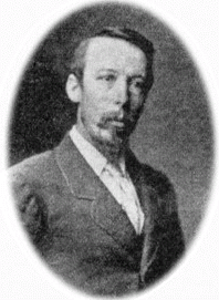
East Mackay | Mayor | Robert
Hague, Mayor (HCS pp.145) |
| Hamilton Drive | Mackay Harbour | ||
| Hamilton Street | North Mackay | ||
| Hamlet Street | Mackay | Shakespeare Character | (opened in 1915 when land reserved for railway line and station). (HCS pp.145) |
| Hammer Street | Slade Point | ||
| Hancock Street | Eimeo | Brisbane Bronco Rugby League Players | Michael Hancock |
| Hanlon Way | Rural View | Queensland Premiers | Named after former Queensland Premier Edward Michael (Ned) Hanlon who served as Premier from 7 March 1946 to 15 January 1952. He died whilst in office. (QPH p. 784.) |
| Hannaford Street | North Mackay | ||
| Hansen Drive | Ooralea | Subdivider's Family | Subdivider, W. Hansen. (HCS pp.153) |
| Hansen Street | Seaforth | ||
| Harbour Road | Mackay Harbour | Road constructed to lead to the Mackay Outer Harbour which was opened in 1939. | |
| Hargreaves Street | Andergrove | ||
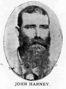
| Harney
Street
|
South Mackay | Mayor | John Harney, Mayor, 1885.(HCS pp.145) |
| Harrier Street | Eimeo | ||
| Harrington Street | North Mackay | ||
| Harris Street | Beaconsfield | ||
| Hart Street | South Mackay | WW2 Casualty | (HCS pp.145) |
| Hartog Street | Andergrove | Australian Explorers | |
| Harvey Street | North Mackay | ||
| Harveys Road | Beaconsfield | ||
| Harvison Street | East Mackay | WW1 Casualty | (HCS pp.145) |
| Harvisons Road | Erakala | ||
| Hassen Court | Mount Pleasant | ||
| Hastings Street | Ooralea | ||
| Hawk Street | Slade Point | Australian Bird | |
| Hayes Avenue | Bucasia | Local Pioneer | Named after Matron Elizabeth Hayes, of the former Cromer Hospital which was located on the corner of Keats and Shakespeare Streets in Mackay. Matron Hayes was one of the first residents in the Bucasia area, near "Kohuna resort, before 1930. (DM 26 May 1993. p.7) |
| Hayes Lane | Mackay | ||
| Hayman Court | Bucasia | ||
| Heaths Road | Glenella | ||
| Heidi Street | Paget | ||
| Heidke Street | Eimeo | ||
| Heinrich Court | Paget | Subdivider's Family | Heinrich Manzlemann, uncle of subdivider. (HCS pp.154) |
| Henderson Street | East Mackay | WW2 Casualty | (HCS pp.145) |
| Henman Street | South Mackay | Original Resident | |
| Henry Court | Beaconsfield | ||
| Herald Court | Andergrove | ||
| Heron Street | Slade Point | Australian Bird | |
| Herrigan Street | Glenella | Local Land Owner | Named after farmer Donald Herrigan who owned land on Richmond Road. (via Email 19/3/2013) |
| Hewitt Way | Glenella | Local Identity | Norman
Hewitt's story.
Dad's parents were - George Edward Hewitt born in Australia, he was a butcher by trade but did farming in Finch Hatton ( his father was born in Northern Ireland & was a doctor) & his mother, Hannah Nicoline Tidemann was born in Denmark, they had 11 children. Eldest brother - Reginald Fulton, 2nd brother - George Edward, 3rd brother - Harold Edward, 4th brother - John Harvey Hewitt. Eldest sister - Irene Sarah, 2nd sister - Fransellar Lillian (Sally), 3rd sister- Edna May, 4th sister - Fira Isabell (Belle), 5th sister - Doris Muriel, then 5th brother - Dad, Norman Hewitt & then the youngest 6th sister - Laurel Joy Hewitt born on 2/10/1927. Dad was born in Mackay on 4th December, 1923 at the Ormond Hospital & moved to Finch Hatton when he was 4 years old & is the last surviving member of his family. Dad's name was chosen because, his mother's cousin had her baby before Dad was born, he was going to have 'Darryl' as his second name but she called him 'Darryl' first, so Dad only has one name. So my Mum (Irene Watters) & Dad called my brother 'Darryl Norman'. I was named 'Andrea' after the actress 'Andrea Leeds' (Mum's choice, as she liked the name). We are both adopted. Dad's family owned a cane farm in Finch Hatton. Coming into Finch Hatton it's the last farm before you reach Finch Hatton on the right hand side before the school. The people that bought it off Dad ( my grandfather) their prodginy had to farm & they were conservationists, they just let it go & it's overgrown with ginny grass now. It was at the top of the hill & you went down the hill & along & there was a blue water gully. Dad's cousin, Harvey Hewitt used to own a farm near the Glenella roundabout, not far from Hewitt Way. Dad started school in 1929, stayed there till 1934, then came to live in Mackay, his Dad had a cane farm & a town house in North Mackay, it used to take 2 hours to get here, he owned a 1927 Whippet with wooden spoke wheels. The family would go to Slade Point to have a holiday. He spent grade 5, when he came back from Finch Hatton at North Mackay State School, then went to intermediate, which is known as Central School now, where he spent grade 6 & 7, got a scholarship, which allowed him to go to high school, he did 2 years & passed there, then had to go to work because of the depression years. He started work at 15 shillings ($1.50) per week, working 5 x 8hr days & a 4 hr day Saturday morning. His Dad owned a ½ block of land in Malcomson St between School St, Malcomson St & Harvey St. He died at the outbreak of WW2 (Sept 3rd 1939), Dad was 15. His Mum gave him the other 1/2 block of land as a wedding present ( valued at 50 pounds ($100) he & Mum, Irene Watters married in 1950. (she died when I was 25 ). Dad has war medals The Pacific Star, for serving in the South Pacific, The 1939/45 Star for serving in the term of the war, The War Medal, The Defence Medal & The Service Medal. He served in New Guinea & Borneo, Milne Bay, Nadzab, Lae, Goodenough Island, Ballikpapen with the RAAF. His Squadron 75 & 76 Kittyhawks was a conglomeration of beaufighters, bombers, yanks (Dad's word) had flying fortresses, liberator bombers. Dad serviced them, fuelled them, fixed them, working on the fuselages, he was called a fitter 2A. Engine guys were called fitter 2E's. The guys that loaded them with bullets were called armourers. The song they sang before they went out each day was - Beside a Papeon waterfall, one bright September day, beside his shattered Kitty hawk, the young PO he lay, and as he lay below the coconut tree, not yet completely dead, I listened to the very last words, the young PO he said " I'm going to a better land, where everything is bright, where whiskey grows on coconut trees & the beetles play all night, there's nothing else to do all day, but sit around & sing, the old barcoo & the women too, oh death where is thy sting". A war story - While driving back from lunch one day at the 33 squadron, driving up a hill, Mick ( from West Wyalong) asked Dad if he knew how to drive, Dad said no I don't have a license, Mick said, now's a good time to learn, & jumped out of the truck. That's how he got his license !! Never did a driver's test, just told them he could drive. When Dad returned from the war he worked at Marsh & Websters in 1946 and worked there till 1964 when he opened Kerrisk's Toy Shop (Wood St next to Roy Andrews' Treasure Store) as manager, then moved to Victoria St opposite Field's (where Centrepoint was) & then to where Struthers Funiture Store is now, & it was opened as a toy & gift shop . After Kerrisk's closed he worked at Field's for 18 months until my Mum died on 30th October 1986. Dad's sporting achievements were playing cricket at school first, then the first real time he played in a team was with Marsh & Websters where he worked the year Harrup Park opened in 1946. His team won the premiership from Bakers Creek at 22 years, the first year after WW2. Then he developed into a fast bowler, & he was picked for their turf team to play at Queens Park on grass wickets. He then represented Mackay to play against Cairns, Ayr, Townsville, Rockhampton & Bundaberg. He was the President of Eastern Suburbs Cricket Club, he was a foundation member & still has the trophies & plaque to prove it !! He retired from cricket at 35 years of age when his son was born. Now he just watches all sport on TV !!! (Courtesy from Hewitt Family via Mackay Regional Council) |
| Hi-Grove Terrace | Andergrove | ||
| Hicks Road | Glenella | ||
| Hicks Street | North Mackay | ||
| High Street | North Mackay | ||
| High Street | Walkerston | ||
| Highland Court | Beaconsfield | Scottish Locations | |
| Highway Place | Glenella | ||
| Hilda Crescent | North Mackay | ||
| Hill Street | North Mackay | ||
| Hillcrest Street | Eimeo | ||
| Hillend Road | Glenella | Hill End was the original name for the area now known as Glenella. | |
| Hillside Terrace | Mount Pleasant | ||
| Hindmarsh Court | Mount Pleasant | ||
| Hinton Street | Mackay | WW1 Casualty | after William Henry Hinton, KIA , 19 August 1917 in Belgium. DM 30/04/1927 |
| Hocken Street | North Mackay | ||
| Hodder Street | North Mackay | ||
| Hodges Road | Shoal Point | ||
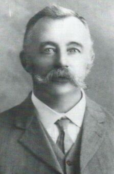
| Hodges
Street
|
South Mackay | Mayor | W.G. Hodges, Mayor 1800, 1890, 1896, 1901.(HCS pp.145) |
| Hoey Street | East Mackay | ||
| Holack Street | North Mackay | ||
| Holland Street | West Mackay | ||
| Holmes Drive | Beaconsfield | ||
| Holts Road | Richmond | ||
| Homebush Road | Walkerston | ||
| Homestead Bay Avenue | Bucasia | ||
| Honeysuckle Street | Andergrove | ||
| Horse and Jockey Road | Meadowlands | Local Hotel | The "Horse and Jockey" Hotel operated near the corner of the Peak Downs Highway and Cowley's Road at Racecourse. It operated from 1869 to 1889. |
| Houdewind Street | Eimeo | ||
| Howard Street | Mackay | WW1 Casualty | Walter
Howard, KIA, WWI. (HCS pp.146) |
| Howland Street | North Mackay | ||
| Hucker Street | Mackay | WW1 Casualty | Mayor
Arthur Hucker's only son, KIA, 1917. (HCS pp.146) |
| Hugh Reilly Court | Mount Pleasant | Local Identity | Hugh Reilly was a well known Real Estate Agent who commenced business after the Second World War. |
| Hughes Street | Glenella | Australian Cricketer | Kim Hughes |
| Hume Street | West Mackay | ||
| Hunter Street | West Mackay | ||
| Hydrangea Court | Beaconsfield | ||
| Hyne
Street
|
Mackay | Former Mayor | Patrick
Maurice Hyne, Mayor 1885,1895. (HCS pp.146) |
| Ian
Wood Drive
|
Dolphin Heads | Mayor | |
| Ibis Street | Slade Point | Australian Bird | |
| Illawarra Court | Beaconsfield | Australian Flora | |
| Illawong Drive | South Mackay | Aboriginal Name | (HCS pp.153) |
| Industrial Street | Mackay | Industrial
Estate. (HCS pp.146) |
|
| Inglewood Close | Andergrove | ||
| Inverness Court | Beaconsfield | Scottish Locations | |
| Investigator Street | Andergrove | ||
| Irving Street | South Mackay | Reef | |
| Island Close | Shoal Point | ||
| Ivana Court | South Mackay | Subdivider's Family | (HCS pp.153) |
| Ivers Street | Bakers Creek | ||
| Ivy Drive | Andergrove | ||
| Jacaranda Street | Andergrove | Australian Flora | |
| Jackson Street | West Mackay | ||
| Jade Court | Glenella | ||
| James Cook Drive | Rural View | Australian Explorers | |
| James Court | Andergrove | ||
| James Croker Drive | Mount Pleasant | Pioneer | |
| James Muscat Drive | Walkerston | ||
| James Street | Mackay | original landowner | believed
to be named after the son of Solomon Watson who owned the original portion
of land. James Alexander Watson born 1870 in Mackay?.(see also Sophia
Street and Watson's Lane). (Correspondence from Bill Watson, great grandson of Solomon Watson and grandson of James Watson , 20/6/2003) |
| Jamieson Street | Seaforth | ||
| Jane Court | Walkerston | ||
| Janelle Court | Andergrove | ||
| Jansen Street | Slade Point | ||
| Janz Court | Slade Point | ||
| Jarman Court | Seaforth | ||
| Jarrah Street | Beaconsfield | ||
| Jasmine Drive | Blacks Beach | ||
| Jasmine Street | Andergrove | ||
| Jason Street | Andergrove | ||
| Jean Court | Bucasia | ||
| Jeffcoat Street | West Mackay | ||
| Jenvey Court | Bucasia | ||
| Jessika Court | Andergrove | ||
| Jewell Street | Mackay | WW1 Casualty | (HCS pp.146) |
| Joanne Street | South Mackay | Subdivider's Family | (HCS pp.154) |
| Joe Johnson Street | Seaforth | ||
| John Court | Andergrove | ||
| John Oxley Avenue | Rural View | Australian Explorers | |
| John Vella Drive | Paget | ||
| Johnson Avenue | Seaforth | ||
| Johnson Street | West Mackay | WW2 Casualty? | (HCS pp.146) |
| Jorgensen Street | Bakers Creek | ||
| Jubilee Street | Mackay | Royal Family | Queens
Victoria's Jubilee. (HCS pp.146) |
| Jukes Street | Slade Point | ||
| Juliet Street | South Mackay | Shakespeare Character | (HCS pp.146) |
| Kaddatz Street | Andergrove | ||
| Karen Court | Ooralea | ||
| Karl Langer Crescent | Mount Pleasant | Town Planner | |
| Karri Court | Beaconsfield | ||
| Karwin Drive | Andergrove | ||
| Kate Street (formerly Maurice Street) | East Mackay | local pioneer | Name
changed from Maurice Street on 12/6/1931 after resolution by Mackay City
Council. Named in memory after Kate Ready daughter of James Ready. First
girl born in Mackay district in 1862. Married Patrick M. Hynes one time
mayor of Mackay. (HCS pp.146) (DM 13 June 1931). |
| Katherine Court | Andergrove | ||
| Kay Court | Glenella | ||
| Kean Street | Andergrove | ||
| Keats Street | Mackay | Poet | (HCS pp.146) |
| Keelan Street | South Mackay | Reef | (HCS pp.146) |
| Keeleys Road | Slade Point | Local Pioneer | Charles Keeley one of Mackay's first residents owned a large parcel of land in the Slade Point Andergrove area. He was also licensee of one of the first hotels in Mackay the "Golden Fleece". |
| Keim Street | Eimeo | ||
| Keithamilton Street | West Mackay | WW2 Casualty | see below. Original spelling combining first and surnames in one word originally to avoid confusion with Hamilton Street in North Mackay. Name corrected to spelling below in 1990's. |
| Keith Hamilton Street | West Mackay | WW2 Casualty | Keith
Hamilton (HCS pp.146) |
| Keller Street | North Mackay | ||
| Kellys Road | Walkerston | ||
| Kemp Street | Bucasia | Local Pioneer? | William George Kemp operated the "Seaview Hotel" from 1887-1894. This was located on the land now occupied by the "Kohuna" resort. |
| Ken White Avenue | Mackay Harbour | Member of Harbour Board and Pioneer Shire Chairman | Ken White was a member of the Mackay Harbour Board from 1955 to 1964. |
| Kenilworth Street | South Mackay | Scottish Locations | "Scottish"
subdivision (Pirie, Forth, Tay, Kenilworth) (HCS pp.146) |
| Kenmore Street | Slade Point | ||
| Kennedy Street | South Mackay | ||
| Kennedy Street | Walkerston | ||
| Kentia Court | North Mackay | ||
| Kenzey Street | North Mackay | ||
| Keswick Avenue | Slade Point | Island | Keswick Island, together with its twin, St Bees Island, was first designated as "L1 Island" by Lieutenant Matthew Flinders, RN, in HMS Investigator in October 1802. Flinders was well out to sea when he passed and probably could not see any separation between the two islands but in any event it was practice in those days to treat closely linked islands as one and give a single name pending further surveys. The two islands were given their individual names from the then English County of Cumberland he brought to the Whitsundays following James Cook's 1770 designation of the group as "The Cumberland Isles". Keswick is a major county town on the edge of the Lake District in Cumbria into which Cumberland was absorbed in 1974.(TWI pp119.) |
| Kidston Avenue | Rural View | Queensland Premiers | |
| Kierra Drive | Andergrove | ||
| Kilgour Street | South Mackay | Reef | (HCS pp.146) |
| Kilkenny Court | Eimeo | ||
| Kimberley Court | Andergrove | ||
| Kindermar Street | South Mackay | Reef | (HCS pp.146) |
| King Street | North Mackay | ||
| Kingfisher Street | Slade Point | Australian Bird | |
| Kinghorn Court | Eimeo | ||
| Kingsford Court | North Mackay | ||
| Kinnon Street | Glenella | ||
| Kintyre Court | Beaconsfield | Scottish Locations | |
| Kippen Street | South Mackay | ||
| Kirkconell Street | Beaconsfield | Scottish Locations | |
| Kirwan Street | Seaforth | ||
| Kiwi Court | Ooralea | Race Horse | (HCS pp.154) |
| Klinger Street | Eimeo | Local Pioneer | Allegedly after Max Klingner who was licensee of the Eimeo Hotel in early 1900's (DM 7 Jan 1983. p.3) |
| Klingner Street | West Mackay | WW2 Casualty | A.C.F. Klinger. Air Force pilot officer. Killed in Adriatic Sea.(DM 7 Jan 1983. p.3)(HCS pp.146) |
| Knight Street | Mount Pleasant | Local Pioneer |
The street was named
after Harry Lawrence Knight, shortly after he died. He lived from
1926-1979. He was a senior Electrical Engineer for the Mackay Electricity Board working on major expansion projects in the 1960's and 1970's. He was also a keen yachtsman, regularly sailing around the Whitsunday Islands, and helping repair electrical generators on the islands along the way. (per Yolande Knight,
04/10/2017) |
| Knobel Street | North Mackay | ||
| Koala Court | Slade Point | Australian Fauna | |
| Kookaburra Street | Slade Point | Australian Bird | |
| Krause Court | Andergrove | ||
| Kristy Crescent | Eimeo | ||
| Kurrajong Court | Beaconsfield | ||
| Kylie Street | Andergrove |